Places & Trails apps

Bring your stories to life through an app
Walkers, cyclists and tour guide passengers love interactive digital experiences that engage, enthral and ultimately enhance a visit.
The Places & Trails app platform allows you to easily create self-guided trails and link stories to points of interest, using our intuitive Content Builder. Place site-relevant multimedia content at visitor’s fingertips.
Read on to discover how feature rich our Places and Trails app platform is, and the emphasis we put on excellent customer support.
Native apps – those designed specifically for iOS and Android devices – can fully utilise the device’s features, such as its camera and GPS, to provide a fast and smooth experience whilst delivering exciting experiences such as location-specific content and Augmented Reality (AR).
Core functionality
As illustrated in the video below, all of our native apps come with the following rich features, as standard:
-
Rich content pages
Pages containing information about places of interest are made from flexible content ‘blocks’ below an optional image gallery, containing one or more images (with optional captions).
Flexible content blocks available for selection include:
- Text
- Expandable/collapsible text (also known as accordions)
- Image (with captions)
- Audio (with captions)
- YouTube links (which are embedded into the page but require an internet connection to play)
- Signpost buttons
- Image compare – select two equal ratio images to automatically fade between
- Image fader – select an image to appear in the camera and manually fade in and out to compare the past with today’s scene
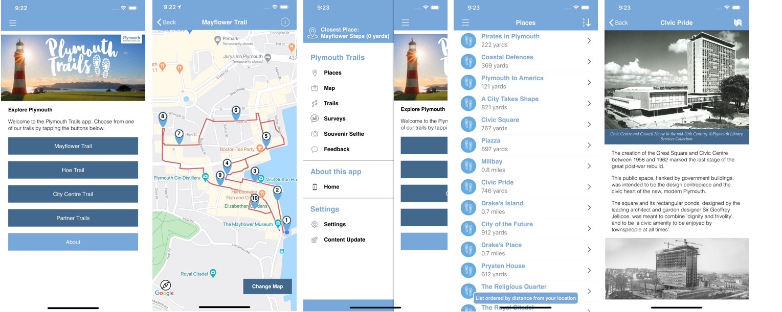
Place pages are accessible from the Map or Trails sections or the optional Place List page, which can be ordered alphabetically or by distance from user (if Location Services is enabled). Places can also be displayed in an optional Badges section, which will group places by the category they have been assigned to.
-
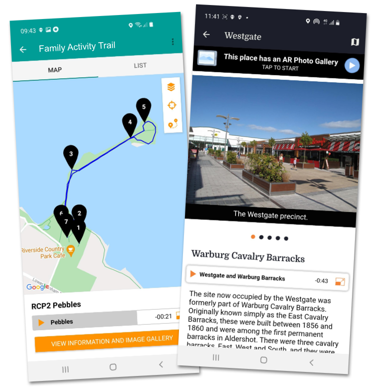
Self-guided trails
Link two or more places in the app to create a trail. Upload the trail route, set the waypoints and add a trail summary. Waypoints can even have their own pop-up window that provide e.g. directions to the next stop. The trail route and associated waypoints are displayed on a map.
Trails are displayed as ‘cards’ – with a summary plus options for distance, time to allows and the number of waypoints – for the user to browse and select.
Our audio tour module can be specified if the focus of your trails will be audio.
-
Interactive mapping
All of our apps utilise Google Maps to display place of interest pins, trail routes (and waypoint pins) and the user’s current location (if Location Services has been enabled by the user). Pins can be filtered by category to display only those related to e.g. historic buildings.
Users can switch between street and satellite views in Google Maps using the ‘Change Map View’ button, and the maps can be zoomed and panned as necessary.
Optional extra – offline maps
Google Maps require a connection to the internet to work as the map tiles are held on Google’s servers. If your project area has patchy signal or you’d like something a little more custom then, as an optional extra, offline maps can be bundled with your app. We often utilise OS Open Data and Open Street Map for this purpose because both provide the option to bundle multiple map tile layers within the app that allow zooming. With offline maps we limit the geographical area to keep the app download as small as possible. We can also bundle illustrative maps, so long as they are geographically accurate i.e. match up with the real world.
Why not check out our Ingleborough Geotrails app which uses OS Open Data map tiles merged with British Geological Society bedrock data to provide a visual representation of the world above and below ground?
-
Real-time tracking
When an app user enables Location Services (during the app install process) the app will use GPS to show the user where they are on the map and their relationship to places of interest. The app can then calculate when a user enters a Place ‘trigger zone’ and notify the user there is content to access.
Via the sliding menu, the app will also display the nearest place to the user, and the distance (as the crow flies). If the app contains a Place List this can be filtered to sort Places by distance from the user (and alphabetically).
GPS can also be utilised to automatically ‘check’ app users into places along a trail; the waypoint pin changes to a pin with a tick for those that have been visited. With our Offers and Rewards plugin (an optional extra) users can be rewarded for completing a trail.
Our app platforms do not store or share any data, including location data.
-
Navigation
All major pages are accessed via the ‘burger icon’ that slides in from the left of the screen. Alternatively, a tab bar system at the bottom of the screen can be employed if 5 menu items or less are needed.
If the sliding menu option is used, a Closest Place indicator will be present at the top of the menu. This highlights the place closest to the device (and distance from it), but will only work if location services has been enabled by the user. Menu items are arranged in three sections, each with their own header:
- The top section contains the core modules of the app e.g. Map, Trails, Place List etc.
- The middle section contains information pages, such as the Home page. Extra pages can be created in the CMS to be added to this section and are made up of flexible content blocks (see Rich content pages)
- The bottom section contains the Settings and Content Update button. The app will automatically check for updates when it is opened. However, the Content Update button is useful for Content Managers who want to instantly pull through and check new content updates.
-
Clear onboarding
The onboarding process starts once the app is downloaded. It begins with the user allowing/denying the app access to location services, notifications etc. Suitable explanations are displayed to explain why these permissions are required e.g. The app uses Location Services to show your position on the screen, tell you how far away places are and alert you when you are near a place of interest. The final stage of onboarding is content download. Some content will be bundled with the initial download – a requirement of both Apple and Android – but the app will regularly communicate with the CMS to check for any updates.
Once onboarding is complete the user can use the app.
-
Real-time content updates
Our intuitive password-protected, web-based Content Management System is simple to use ensuring you can easily edit existing content and add new updates when you need to. Once the changes have been made they will be pushed to your app in real time.
Plug in extra functionality
Our platform is very flexible and it is easy to add extra functionality from the outset or added in as part of an update. We have a range of optional extras that can be ‘plugged in’ or if you have something else in mind then let us know and we’ll bring that idea to life.
Augmented Reality
Offline mapping
Quizzes
Photo filters
Offers & Rewards
Language selector
Audience segments
Premium content
Custom feature
Tried and trusted
If you have downloaded more than one of our apps you will recognise the architecture (layout) is very similar. This templated approach allows us to keep costs low, but flexible enough to customise functionality and apply branding to make each app unique. You are welcome to supply your own app assets e.g. app icon or simply share your branding guidelines (or preferred colours) with us and we’ll do the rest.
App builder
Our Content Management System (CMS) is so easy to use. Even if you haven’t used a CMS before we are confident you will be uploading your places and trails content in no time. We provide online training, which is recorded and shared so you can refer back at any time.
Analytic data
We will provide you with access to our analytics package. Understand who many downloads your app has had and build up a picture of which places and/or trails are most popular, and how many are triggered by GPS and those manually selected.
Outstanding support
Our primary objectives are to ensure you get value for money, are guided clearly through the process and that your time with us is fulfilling and exceeds expectations. We are UK-based and always respond promptly to support requests. We rate very highly for customer satisfaction as our latest survey reveals.
“AT Creative are really easy to work with, being responsive and understanding the needs of the project and our objectives. The trails app solution is straightforward and offers a user friendly experience in addition to being practical to use and upload content to. The AT team were always on hand to offer advice and support. We’re delighted with the Digital Trail and it will be great asset for visitors to the Mayflower destinations during the commemoration year and beyond.”
Emma Tatlow, Mayflower 400 National Visitor Project Manager